Posted: 07 Sep 2017 08:36 AM PDT
Piggin Peutinger Diagram
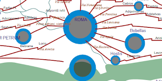
The most famous map in the world is the Tabula Peutingeriana, a Roman chart of roads and seas. In 2007, UNESCO placed it on its Memory of the World Register, a global list of 301 documents (as of 2013) which are irreplaceable to comprehend our recent and distant past.
The 12th-century sole copy of the chart is locked in a library vault in Vienna, Austria. So the only decent access you'll get is either to look up a high-resolution photograph (see Richard Talbert's Map Viewer) or check out the the first fully digital edition. The latter, which is my work, arrived online today, and it's #free.
With the digital edition, your browser can:Back in March I foreshadowed this edition, which has been the work of several months and is based on the phenomenal earlier work of Talbert and Tom Elliott (@paregorios). The credits line says:
- search for any of the 3,000+ names (press Ctrl + F)
- use live links (signaled by a hand cursor) to get more info
- zoom in (press Ctrl and mouse wheel) without loss of quality
- reveal manuscript errors (hover cursor over yellow boxes)
The live links lead to the interpretative database which Richard Talbert very generously placed online as a free resource several years ago. The colors of the lettering and roads are not medieval or ancient, but my own choice to make the document more accessible. Other alterations to give it fresh life include reducing spaced-out lettering to make it easily legible. For the sake of a compact file and fast loading I am not reproducing the little vignettes that show towns, temples and spas.
- Richard Talbert and Tom Elliott (transcription, projection, colors, original typology);
- Jean-Baptiste Piggin (replot, object modelling, interpretational overlayers, revised typology).


